
🎉 Big Changes Ahead: We're moving to Qt6 and Launching #QGIS 4.0!
https://blog.qgis.org/2025/04/17/qgis-is-moving-to-qt6-and-launching-qgis-4-0/
🎉 Big Changes Ahead: We're moving to Qt6 and Launching #QGIS 4.0!
https://blog.qgis.org/2025/04/17/qgis-is-moving-to-qt6-and-launching-qgis-4-0/
 New OSM Contribution Statistics Tool
OSM Wrapped - Version 1.0 released. Kennedy Kambi and Joseph-Munyenze's team has released a cool tool that visualizes your annual contributions to OSM using the #HDYC platform by @pascal_n.
Check it out and use #osmwrapped https://osmwrapped.com
#osmwrapped #osm #openStreetMap #gis #gischat #mapstodon #maps #contributor
New Map Alert 🗺️
Natural Resources Canada has released a new StoryMap: Canada’s Evolving Geographical Names. It explores over 100 years of name changes including the recognition and restoration of indigenous place names. Check it out when you can.
https://ow.ly/e52a50WJ9Fu
#naturalresourcescanada #gis #gischat #mapstodon #Indigenous #map #maps #GNBC #geographicalnames
New Atlas Alert 🗺️
The Atlas of community and citizen science initiatives contributing to marine mammal research is available for review. https://bit.ly/CitSciMap
There is a final call for submissions and final checks by September 30th. Please submit comments or questions to Emily Hague [email protected]
#science #marinemammals #mapstodon #atlas #blueconnect #HorizonOceanMission #gischat #marinebiology #cetaceans
🛰️ New Imagery Press Release 🛰️
The NISAR (NASA-ISRO Synthetic Aperture Radar) satellite sends "first light" images.
https://www.jpl.nasa.gov/news/nasa-isro-satellite-sends-first-radar-images-of-earths-surface/
#NISAR #NASA #ISRO #remotesensing #gischat #gis #satellite #satellites #SAR #JPL
🛰️ ICYMI New Imagery Press Release 🛰️
EUMETSAT has released the first Earth images from its METimage instrument on board the recently launched Metop Second Generation A1 (Metop-SGA1) satellite.
https://www.eumetsat.int/metimage-delivers-spectacular-first-images
HT to @niklasjordan who runs @eumbot which posts live natural color composites of EUMETSATs Meteosat satellites at 15-minute intervals.
#remotesensing #satellite #satellites #eumetsat #eumetsat #earthobservation #gis #gischat
Because today is the June #solstice, here is my 2020 animated map of this solstice’s day-night cycle rendered using the #CahillConcialdi map projection, which is my most favorite.
Grab the file here: https://commons.wikimedia.org/wiki/File:Cahill%E2%80%93Concialdi_projection_(Natural_Earth_I)_day-night_animation_at_June_solstice.gif
Putting this out into the fedi in the hopes I don't forget about it in the long run: mnemonic device maps.
You know how when you're learning geography and the task is memorizing nations, capitals, etc on a map? With dozens to remember, mnemonic devices are handy. As a cartographer, one day I'd like to make some maps that a) illustrate such devices and b) enable the user to make up their own.
This is something I'd love to do as a freelancer.
#gischat #cartography #maps
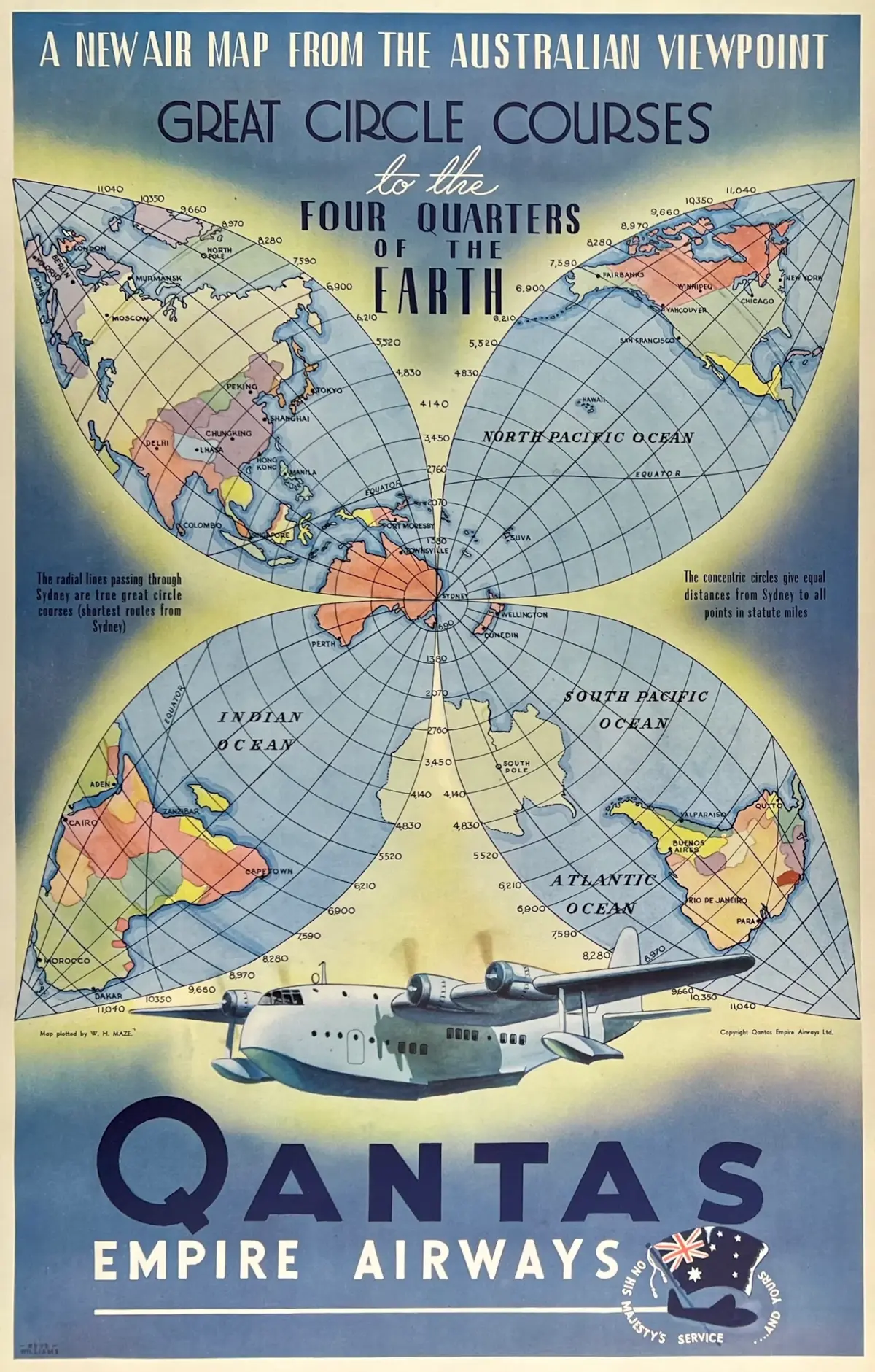
🧵 1/2: I recently saw this vintage #Qantas poster with a unique “flower” map projection centered on #Sydney (1st image). I love how it almost neatly divides the four largest continents (Eurasia, Africa, and North and South America) into the 4 “petals”.
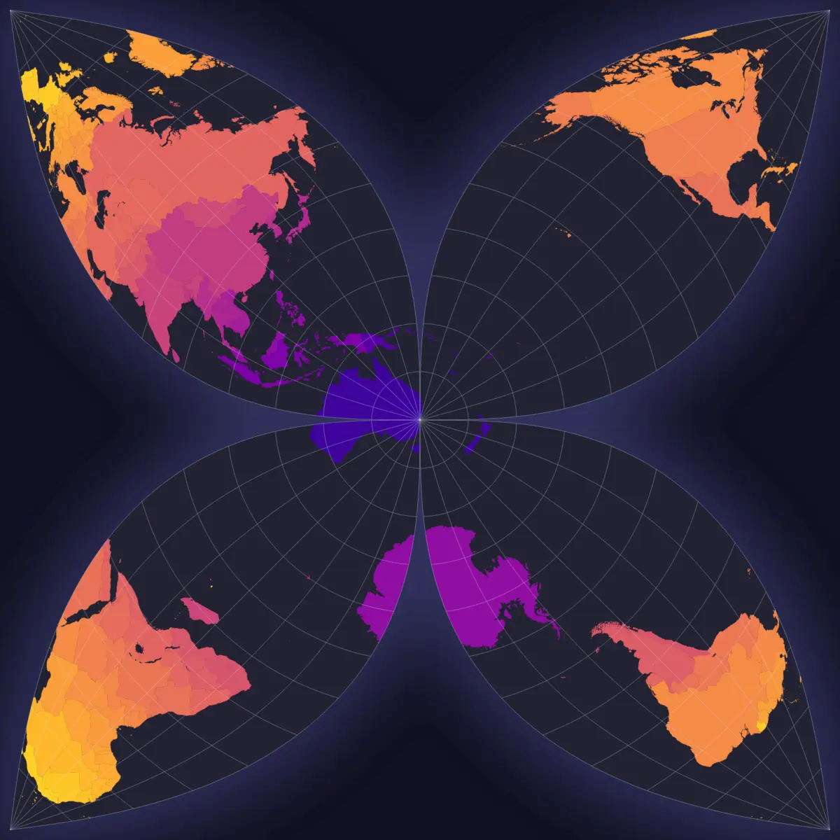
I sorta became obsessed and wondered if I could recreate it using my mapmaking and coding skills.
Some days of tinkering, coding, and mathing later, I think I managed to do it! (2nd image) 🎉🗺️







_day-night_animation_at_June_solstice.gif)